-
 Lyles Family Home
 The Lyles farm was located within the J.M. Moses Survey and consisted of sixty-three acres of land.
-
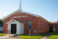
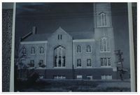 Allen AME Chapel, Fort Worth
 Photo of Allen AME Chapel in Fort Worth. Allen AME was organized in 1873.
-
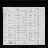
 1865 Tax Assessment Denton County
 Tax Assessment of Denton County in 1865 depicts property of Francis Davis, showing a lack of slaves.
-
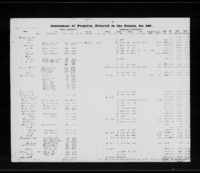
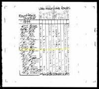
 1864 Tax Assessment Denton County
 Tax Assessment of Denton County in 1864 depicts property of Francis Davis, including slaves.
-
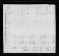
 1863 Tax Assessment Denton County
 Tax Assessment of Denton County in 1863 depicts property of Francis Davis, including slaves.
-
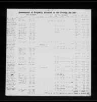
 1862 Tax Assessment Denton County
 Tax Assessment of Denton County in 1862 depicts property of Francis Davis, including slaves.
-
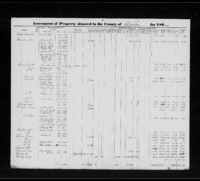
 1861 Tax Assessment Denton County
 Tax Assessment of Denton County in 1861 depicts property of Francis Davis, including slaves.
-
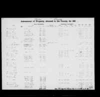
 1860 Tax Assessment Denton County
 Tax Assessment of Denton County in 1860 depicts the property of Francis Davis
-
 Map of AME Churches in North Texas
 This a map of AME churches in North Texas that were known to have organized between 1870 and 1930 that exist as of 2018.
-
 1859 Tax Assessment Denton County
 Tax Assessment of Denton County in 1859 depicts Francis Davis and two enslaved persons: Harriet and Gilbert
-
 Willie Hudspeth discusses the name of St. John's Cemetery
 Oral history clip of Willie Hudspeth talking about St. John's Cemetery
-
John White discusses growing up around Pilot Point
Oral history clip of John White discussing growing up around Pilot Point
-
John White discusses cemetery name
Oral history clip of John White from Pilot Point discussing the origins of St. John's Cemetery and its name
-
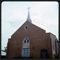 Miles Memorial CME Church
 A photo of Miles Memorial CME Church, the first CME church organized in Texas, which is located in the historically black section of Marshall, New Town.
-
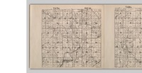 Land Map of Round Prairie Township in Missouri
 Land map depicts the land once owned by Gerrard Davis under the name Rice, the married name of one of his daughters, in the upper left portion of section 34.
-
 Land Grant of Gerrard Davis (May 1831)
 Gerrard Davis was patented new land in Missouri. In 1826 and then again in 1831 he received 80 acres, both in the northwest quarter of township forty seven, range ten west in section thirty four of Callaway County, Missouri. Today, this land is located a half mile west of I-54 and approximately four miles southwest of Fulton, Missouri.
-
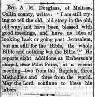 Emberson Chapel, Pilot Point (1886)
 Emberson Chapel of Pilot Point, Texas reports adding eight member to their congregation.
-
 1844 State Census of Gerrard Davis
 State Census, which throughout Callaway County did not depict enslaved persons, shows Gerrard Davis and his family in 1844 in Round Prairie Township, MO.
-
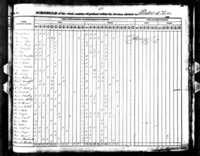 1840 Census of Gerrard Davis
 1840 Census Depicts the family of Gerrard Davis on line 1: Gerrard (40-50), Amelia (30-40), Francis (15-20), Elizabeth (10-15), Charles (10-15), Elias (5-10), Mary (5-10), Richard (0-5), Margaret (0-5).
-
 Land Grant of Gerrard Davis (June 1826)
 Gerrard Davis was patented new land in Missouri. In 1826 and then again in 1831 he received 80 acres, both in the northwest quarter of township forty seven, range ten west in section thirty four of Callaway County, Missouri. Today, this land is located a half mile west of I-54 and approximately four miles southwest of Fulton, Missouri.
-
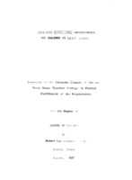 Equalizing Educational Opportunities for Children In Denton County
 In this masters thesis, you will find tables of attendance, school systems, bus systems, and income inequality. Robert Lee Proffer wrote this thesis in 1937, reviewing the education system across all areas. From whites to blacks and urban to rural, all categories are covered within the Denton County system. Through his findings we can imagine what the education system was like for both whites and blacks across all of Denton County. Through tables, data analysis, and maps you can see the differences and similarities in both urban and rural areas. There was 6.6% of the Denton County population who were African American and 93.1% were native whites. However, 70.4% were classified as living in rural areas which is where the most disconnect in education occurs. The biggest differences were made in school districts that were urban and rural, since the rural areas did not have access to as many opportunities and advancements. This is another reason why we believe that African American communities gathered around their church and school for support. Seeing the differences in education can allow us to determine what it was like for students and teachers.
-
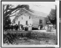 African American men, women, and children in front of southern churches.
 Photographs depicting multiple southern African American churches and their parishioners.
-
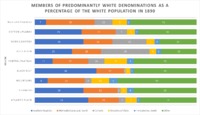 Members of Predominantly White Denominations as a Percentage of the White Population in 1890
 Members of Predominantly White Denominations as a Percentage of the White Population in 1890
-
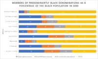 Members of Predominantly Black Denominations as a Percentage of the Black Population in 1890.
 Members of Predominantly Black Denominations as a Percentage of the Black Population in 1890.
-
Willie Hudspeth's feelings on the state of the cemetery
Oral history clip of Willie Hudspeth talking about St John's Cemetery